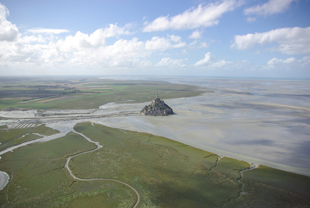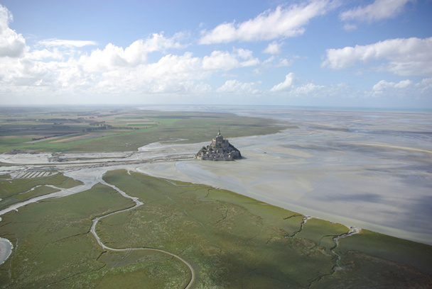
Shades of green, gray, beige….Where is the earth, where is the sea, in this mixture of meadows, polders, and strangely traced veins? DR : J-F.R.
The Japanese are crazy about it.
At the Val Saint-Père airfield in Avranches, they are the most eager, to the extent that some companies specialized in flying over the Mont-Saint-Michel have translated in ideograms some of their promotional material.
This is the case of Régis Mao, an experience seasonal pilot of ultra light aeroplanes and autogyres.
What is the “autogyre”? A sort of roofless two-seated helicopter, that can rise up to 6000 meters high and reach a speed of 130 km/h.
In other words, the ideal aircraft (since its less affected by turbulences like an an ultra-light) to fly over this wonder.
Once the helmet and seatbelt secured, just two minutes after a smooth take-off, there we are, like birds, looking down at the sheep in the salt-meadows.
The view is spectacular during the low tide. As the sea sets back (the tides here are the biggest in Europe, reaching up to 14 m in tidal range) its multitude of tidal creeks appear giving the spectacle of an immense network of veins.
Shades of green, gray, beige….Where is the earth, where is the sea, in this mixture of meadows, polders, and strangely traced veins?
On this flat surface, the solid “stone” of the Mont Saint-Michel seems surreal, giving a reassuring familiarity in this infinite landscape
A territory domesticated by humans and unique in Europe
Barely shaken up by the turbulences, accompanied by the smooth purring of the motor, we fly over the huge hydraulic construction and imposing parking area.
We then skip over the last bit of the Couesnon river to end up on the bay on which reflect the shadows of furtive white clouds.
The island Tombelaine seems nonexistent, like a tiny speck abandoned in the sand.
At the bottom, three or four blacks spots near a tidal creek hint at a family of seals relaxing.
Now we’re above the Hermelles. There seems to be a lot going on the sandy foreshore. It makes sense since we’re on top of the mussel beds, whose ordered alignment we can make out.
Walking fishermen, mussel growers on tractors, hikers, small boarding zones: the low tide brings a world of workers and tourists on invisible trails.
A forgotten engine buried in the sand serves as a reminder of the dangers and necessity to respect the strict hours imposed by the tides.
On the return flight, we notice dried up ponds along with buried shacks for hunting on the hide.
Only from the perspective of the skies, a memorable experience, can we truly feel the diversity of this unique European territory that was domesticated by humans.
Mont Saint-Michel Tourism Office
50170 La Mont Saint-Michel
02 33 60 14 30
www.ot-montsaintmichel.com
For details and news on the D-Day site visit: le70e-normandie.fr/pratique/comment-jy-vais/
50170 La Mont Saint-Michel
02 33 60 14 30
www.ot-montsaintmichel.com
For details and news on the D-Day site visit: le70e-normandie.fr/pratique/comment-jy-vais/


![Vraies tendances ou illusions : radiographie d'un monde en recomposition [ABO] Vraies tendances ou illusions : radiographie d'un monde en recomposition [ABO]](https://www.tourmag.com/photo/art/large_16_9/93540809-65355472.jpg?v=1767624066)


